


Content block block-2017745546-1791601724
What Is El Niño
El Niño is a natural climate pattern defined by the warming of ocean surface temperatures in the central and eastern tropical Pacific Ocean. During normal conditions, trade winds blow west along the equator and push warm water toward Asia. During an El Niño event, these trade winds weaken or reverse direction. This change allows warm water to pool back toward the Americas and can shift weather patterns and bring wetter, more intense winters to California.
Occurring every two to seven years, this change alters global weather patterns that can bring extreme heat and/or heavy rainfall and flooding to the Southwest U.S., including California and Orange County.
Why El Niño Is Important
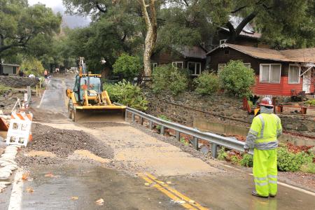
Southern California can expect a significantly wetter-than-average winter, heavier rainfall, and severe coastal impacts driven by an intensifying or "super" El Niño. Federal forecasters say El Niño is strengthening, with a greater than 90% chance of a very strong event this fall and winter. The NOAA Climate Prediction Center indicates that Southern California has the highest odds in the state for above-normal rainfall, starting early in the rainy season (November/December) and lasting through spring.
Unusually high waves and powerful swells coupled with high tides have already stripped sand from beaches from Malibu to Carlsbad, a trend that may continue depending on future winter storms.
For California, that can mean repeated rounds of heavy rain, strong winds, mountain snow, flooding, landslides, debris flows, large waves, and coastal flooding, especially when storms hit during very high tides. These impacts can lead to road closures, power outages, damage to infrastructure, and evacuations.
El Niño Weather Impacts
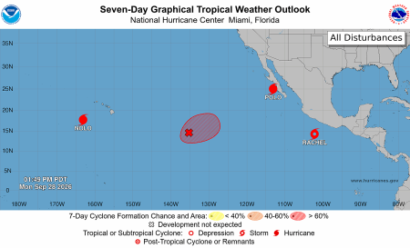
Between June and September 2026, there have been more than two dozen tropical storms and hurricanes in the Pacific Ocean alone that can attributed to a stronger El Niño season. Some have made landfall in Hawaii and caused major damage to the islands, including tropical storm Lala and hurricanes Genevieve, Lowell, and Nolo. Others have caused intense weather patterns along the Mexico and U.S. coasts, including tropical storm Marie (briefly a hurricane) and hurricanes Norbert, Odalys, and Polo.
Another El Niño weather impact is a Kelvin wave, a massive, non-perceivable wave in the ocean that moves from west to east along a boundary like the coastline or the earth’s equator. Unlike normal ocean waves that crash on the beach, Kelvin waves are hundreds of miles wide and can take weeks to cross an entire ocean. Kelvin waves are the main triggers for El Niño weather patterns because they move massive volumes of water from continent to continent, causing droughts in some parts of the world and heavy flooding in others. A Kelvin wave reached the Southwest U.S. coast in early October, causing a gradual rise in sea level of five to 12 inches, and continued north toward Northern California and Canada.
The combination of a Kelvin wave, high or king tides, and/or storm surges can threaten coastal communities and increase flooding risks.
Links in this section relate to Body